Monday, April 10, 2023

Current Land Use Map of Germantown, Maryland


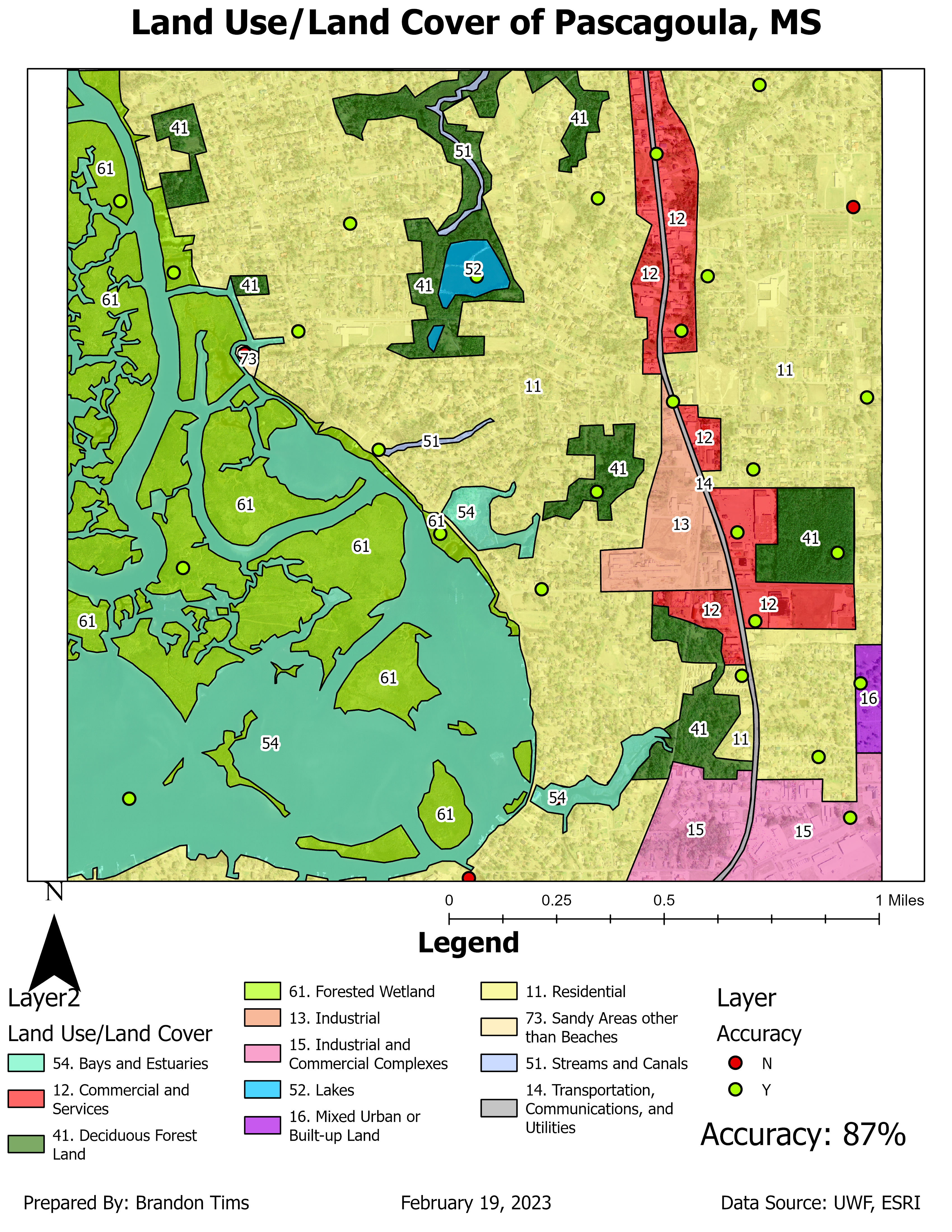
 This map displays the land use classification area for Germantown, Maryland. Over the past 30 years, Maryland’s population has increased by 30% while land consumption has increased by 100% . The City of Germantown wants to follow the Governor’s advice and work toward Maryland’s “Smart, Green and Growing Initiative.” Using the combination of the bands Red: 4, Green: 5, Blue: 6 created the image for the map.
 The class names and color are located under the class names section with the area of each class to the left in acres. The distance image represents the Spectral Euclidean Distance, the brighter a pixel, the greater the difference. Urban/Residential areas are located in pink with an area of 1,999 acres. Agriculture areas are located in cyan with an area of 11,538 acres. Water areas are located in blue with an area of 639 acres. The rest of the classes are located under the class name legend.

Monday, March 27, 2023


 For this weeks lab we used different band combinations to identify different features in Northwest Washington. 

The image on the left shows bare soil features on the map, the areas covered in the red/brownish color are the features covered by bare soil. This was found using the TM False Natural Color which uses the band combination of RGB: 5, 4, 3. 

The image in the middle shows snow features on the map, the areas covered in the yellow and purple colors indicate areas where snow has fallen or could collect due to elevation. This was found using the band combination of RGB: 2, 4, 5. 

The image on the right shows the urban features on the map, the areas covered in grey color are features covered by urban features/development. This was found using the TM False Color IR band combination of RGB: 4, 3, 2.

Monday, March 6, 2023

Land Use Classification Washington State Forest


 For this weeks lab I explored the ERDAS Imagine 32-bit software. I identified how to utilize a subset of the data in the software and export that subset of data to ArcGIS Pro and also identified multiple ways to save, export, and zoom into the different views. The map I created above is the subset of an original image I had explored in ERDAS Imagine 32-bit and after exporting the subset data file into ArcGIS pro, I created a map of the subset area with the land information categorized by the "Class_Names" in the legend and additionally, the area in hectares corresponding to those different land classifications to the right of them in the legend.

Sunday, February 19, 2023

Land Use/Land Cover of Pascagoula, MS


 This map displays the land use/land cover of the Pascagoula, MS area. It also displays the level of accuracy that each land use/land cover zone has by using point features to show if these areas are zoned correctly in the correct areas. The map I produced has a 87% point accuracy which is relatively pretty good accuracy. 

Thursday, February 2, 2023

Aerial Photograph Depicting Various Tones/Texture

This map is classified in two categories tone and texture. For tone they are classified by: very light, light, medium, dark, very dark. For texture they are classified by: very fine, fine, mottled, coarse, and very coarse. 

For this map I identified features and objects by: shape size, shadows, pattern, and association. For shape size I identified three features: the parked cars, the main road and the restaurant. The main roads shape was easily identifiable and so were the tiny parked cars in the parking lot. The restaurants shape was also easy to identify as it was the largest building along the beach. For shadows I identified objects by their shadow such as the water tower, the sign to a store and a light pole along the road. For pattern I looked for objects that had a similar pattern to them such as: the ocean (because of wave action), the parking lot, and the beach housing community to the east in the image. Finally I identified objects by association and found: the pier, the hotel pool (in middle of hotel), and the community pool for the housing on the east side of image. 


Module 7 Google Earth

 Google Earth For this week's lab we were tasked with creating a dot density map of south Florida in Google Earth. The map also includes...